Charleston County Gezeiten für heute, morgen und die Woche

Ebbe und Flut Charleston County, South Carolina, United States

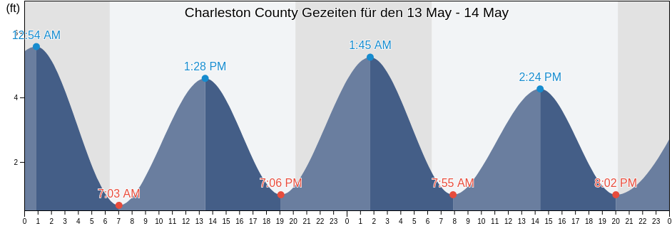
Mittwoch 24 April 2024, 02:56 EDT (GMT -0400). Die Tide fällt derzeit in Charleston County. Wie Sie der Gezeitentabelle entnehmen können, ist die höchste Tide von 5.91ft um 21:41 und die niedrigste Tide von 0.33ft ist um 03:13. Klicken Sie hier, um die Gezeiten von Charleston County für diese Woche anzuzeigen.

Nächste Hochwasser

Die nächste Hochwasser ist um
09:16

Nächste Niedrigwasser

Die nächste Niedrigwasser ist um
03:13

Tidenkalender für Charleston County

Gezeitenkalender für Charleston County diese Woche
Tag Tidenkalender für Charleston County Sonnenaufgang und Sonnenuntergang
1. Gezeit 2. Gezeit 3. Gezeit 4. Gezeit
Mi. 2403:13
0.33 ft
09:16
4.92 ft
15:11
0.33 ft
21:41
5.91 ft
06:39 19:57
Do. 2503:53
0.33 ft
09:50
4.92 ft
15:46
0.33 ft
22:16
5.91 ft
06:38 19:58
Fr. 2604:33
0.33 ft
10:24
4.59 ft
16:22
0.33 ft
22:54
5.91 ft
06:37 19:58
Sa. 2705:14
0.66 ft
11:03
4.59 ft
17:01
0.33 ft
23:36
5.91 ft
06:36 19:59
So. 2806:00
0.66 ft
11:48
4.59 ft
17:47
0.66 ft
06:35 20:00
Mo. 2900:26
5.58 ft
06:50
0.66 ft
12:42
4.59 ft
18:41
0.66 ft
06:34 20:00
Di. 3001:24
5.58 ft
07:47
0.66 ft
13:46
4.59 ft
19:46
0.66 ft
06:33 20:01

Beste Angelzeiten für Charleston County heute Heute ist ein ausgezeichneter Angeltag

Starke Angelzeiten

Von 06:55 bis 08:55

Entgegengesetzter Monddurchgang (Mond unter)

Von 19:54 bis 21:54

Monddurchgang (Mond auf)

Schwache Angelzeiten

Von 06:19 bis 07:19

Monduntergang

Von 20:24 bis 21:24

Mondaufgang

Klicken Sie hier, um die Angelzeiten von Charleston County für die Woche anzuzeigen.

Aktuelles Wetter in Charleston County

Wolkenlos

Wetter

Bewölkung 0%
Temperatur

Temperatur

61°F
Min 60°F/Max 70°F
Wind

Wind

11 mph
Windböen 19 mph
Feuchtigeit

Feuchtigeit

61%
Taupunkt 47°F

Klicken Sie hier, um das Wetter in Charleston County für die Woche zu sehen

Das heutige Wetter in Charleston County

Die Sonne geht auf um 06:39 und der Sonnenuntergang wird stattfinden um 19:57. Es wird 13 Stunden und 18 Minuten Sonne geben und die durchschnittliche Temperatur beträgt 66°F. Zur Zeit beträgt die Wassertemperatur 64°F und die durchschnittliche Wassertempertur beträgt 64°F.

Wetter für Charleston County heute
0 h 3 h 6 h 9 h 12 h 15 h 18 h 21 h 24 h
WolkenlosWolkenlosWolkenlosSonnigTeilweise bewölktTeilweise bewölktTeilweise bewölktTeilweise bewölktTeilweise bewölkt
61°F67°F66°F67°F66°F69°F66°F67°F65°F

Klicken Sie hier, um das Wetter in Charleston County für die Woche zu sehen

Mehr Gezeiten- und Meeresinformationen für Charleston County

Regionen und Städte in Charleston County, South Carolina, United States

Abbapoola Creek EntranceFolly River (North Folly Island)Patriots Point
ACE BasinFolly River Bridge (Flooy Island)Pea Island
Army DepotFolly River Bridge Flooy IslandPennys Creek (West Entrance)
Ashley River (I-526 Bridge)Folly River North Folly IslandPennys Creek West Entrance
AwendawFort JohnsonPleasant Point
Battery southwest ofFort SumterPlum Island
Bees Ferry BridgeFort Sumter Range Buoy 14Point Of Pines
Ben Sawyer BridgeFort Sumter Range Buoy 2Price Creek (North Capers Island)
Ben Sawyer Bridge ICWWFort Sumter Range Buoy 20Price Creek North Capers Island
Big Paradise IslandFort Sumter Range Buoy 4Rathall Creek entrance
Bluff PointFort Sumter Range Buoy 8Rebellion Reach 0.8 n.mi. N. of Ft. Sumter
Botany Bay IslandFt. Sumter 0.6 n.mi. NW ofRemley Point 0.2 mile northwest of
Bowen IslandGoose Creek entranceRockville (Bohicket Creek)
Breach Inlet (Isle Of Palms)Goshen Point SE of Wadmalaw RiverRockville Bohicket Creek
Breach Inlet Isle Of PalmsGoshen Point south of Wadmalaw RiverS.C.L. RR. bridge 0.1 mile below
Buck Hall (Awendaw Creek)Hamlin Creek (Isle Of Palms)S.C.L. RR. bridge 1.5 miles above
Buck Hall Awendaw CreekHamlin SoundSandblasters (Pennys Creek)
Buoy '19'Harbor River EntranceSandblasters Pennys Creek
Buoy 19 off Nowell CreekHo-non-wah Boy Scout Camp (Bohicket Creek)Seabrook Beach
CainhoyHobcaw PointSeabrook Island
Cainhoy Wando RiverHog Island ChannelSecessionville Secessionville Creek
Capers Creek South Capers IslandHog Island Reach Buoy 12Shem Creek
Castle Pinckney 0.4 mile south ofHog Island Reach SW of Remley PointShipyard Creek (0.8 mile above entrance)
Castle Pinckney 0.6 mile southwest ofHollywoodShipyard Creek entrance
CharlestonHorlbeck Creek 0.2 mile above entranceShutes Folly Island 0.4 mile west of
Charleston (customhouse Wharf)Horlbeck Creek 2.5 miles north ofShutes Reach Buoy 8
Charleston Harbor (off Fort Sumter)Horse ReachSnake Island
Charleston Harbor EntranceI 526 BridgeSol Legare Island
Charleston Hbr. ent. (between jetties)Isle of PalmsSouth Ashley Bridge
Church Creek BridgeIsle Of Palms PierSouth Capers Island
Church FlatsJack Creek EntranceSouth Chan. 0.4 mi. NW of Ft. Johnson
Clouter Creek (North Entrance)James Island Creek (1 mi. above ent.)South Chan. 0.8 mi. ENE of Ft. Johnson
Clouter Creek (South Entrance)Johns Island (Church Creek)South Channel Buoy 32
Clouter Creek North EntranceJohns Island Airport south ofSouth Dewees Island (Dewees Inlet)
Clouter Creek South EntranceJohns Island BridgeSouth Dewees Island Dewees Inlet
Cosgrove BridgeJohns Island Church CreekSouth Jetty break in
Customhouse ReachKiawah IslandState Hwy. 7 bridge
Customhouse Reach off CustomhouseKiawah River BridgeStono Inlet
Daniel Island BendLeadenwah Creek (3 Mi. Above Entrance)Sullivans I. 0.7 mi. NE of Ft. Sumter
Daniel Island ReachLimehouse BridgeSullivans Island
Daniel Island Reach Buoy 48MeggettSullivans Island (outer Coast)
Deveaux Banks off North Edisto River entranceMoores Landing (Sewee Bay)The Cove (Fort Moultrie)
Drayton Bees FerryMoores Landing ICWW Sewee BayThe Cove entrance on the Cove Range
Drum Island 0.2 mile aboveMorris IslandThe Cove Fort Moultrie
Drum Island 0.4 mile SSE ofMount PleasantThe Washout
Drum Island east of (bridge)North CharlestonTown Creek 0.2 mile above bridge
Drum Island Reach off Drum I. Buoy 45North Dewees Island (Capers Inlet)Town Creek Lower Reach
Duck IslandNorth Dewees Island Capers InletWadmalaw Island Wadmalaw River entrance
Elliott Cut EntranceNorth Edisto River entranceWando River Upper Reach Turning Basin
Elliott Cut west endNorth Jetty 0.8 mile southeast ofWappoo Creek
Filbin Creek ReachNowell CreekWappoo Creek Highway Bridge
Filbin Creek Reach 0.2 mile east ofNowell Creek entranceWappoo Creek off of
Filbin Creek Reach Buoy 58Oak Branch (Bohicket Creek)West Marsh Island 0.1 mile east of
Five Fathom Creek EntranceOak Branch Bohicket CreekWharf Creek Entrance
Folly BeachOcella Creek (2 Mi. Above Entrance)Woods Point
Folly Beach PierOld Capers Landing (Capers Island)Woods Point SE of
Folly Creek (Hwy. 171 Bridge)Old Capers Landing Santee Pass Capers IslandWoodville
Folly I. Channel N of Ft. JohnsonOrdnance ReachYellow House Creek
Folly Island (outer Coast)Parker Island (Horlbeck Creek)Yellow House Landing 1 mile NW of
Folly Reach Buoy 5Parker Island Horlbeck CreekYonges Island