Georgetown County Gezeiten für heute, morgen und die Woche

Ebbe und Flut Georgetown County, South Carolina, United States

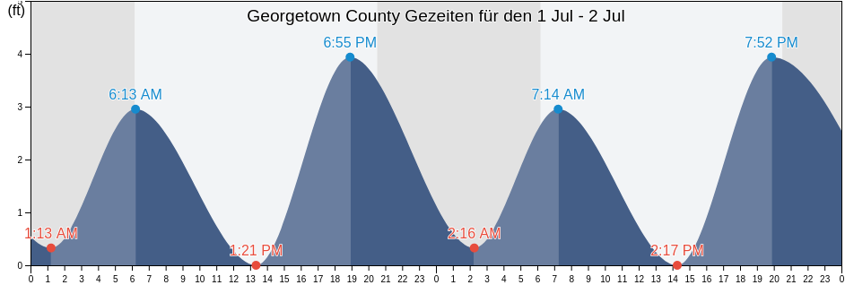
Samstag 29 Juni 2024, 14:59 EDT (GMT -0400). Die Tide fällt derzeit in Georgetown County. Wie Sie der Gezeitentabelle entnehmen können, ist die höchste Tide von 3.61ft um 16:54 und die niedrigste Tide von 0ft war um 11:27. Klicken Sie hier, um die Gezeiten von Georgetown County für diese Woche anzuzeigen.

Nächste Hochwasser

Die nächste Hochwasser ist um
16:54

Nächste Niedrigwasser

Die nächste Niedrigwasser ist um
00:07

Tidenkalender für Georgetown County

Gezeitenkalender für Georgetown County diese Woche
Tag Tidenkalender für Georgetown County Sonnenaufgang und Sonnenuntergang
1. Gezeit 2. Gezeit 3. Gezeit 4. Gezeit
Sa. 2904:13
3.28 ft
11:27
0 ft
16:54
3.61 ft
06:10 20:31
So. 3000:07
0.33 ft
05:12
3.28 ft
12:24
0 ft
17:55
3.61 ft
06:11 20:31
Mo. 101:13
0.33 ft
06:13
2.95 ft
13:21
0 ft
18:55
3.94 ft
06:11 20:31
Di. 202:16
0.33 ft
07:14
2.95 ft
14:17
0 ft
19:52
3.94 ft
06:12 20:30
Mi. 303:13
0.33 ft
08:12
2.95 ft
15:11
-0.33 ft
20:47
3.94 ft
06:12 20:30
Do. 404:07
0.33 ft
09:08
2.95 ft
16:03
-0.33 ft
21:39
3.94 ft
06:13 20:30
Fr. 504:56
0.33 ft
10:00
2.95 ft
16:52
0 ft
22:27
3.94 ft
06:13 20:30

Beste Angelzeiten für Georgetown County heute Heute ist ein durchschnittlicher Angeltag

Starke Angelzeiten

Von 06:47 bis 08:47

Monddurchgang (Mond auf)

Von 19:02 bis 21:02

Entgegengesetzter Monddurchgang (Mond unter)

Schwache Angelzeiten

Von 00:48 bis 01:48

Mondaufgang

Von 13:46 bis 14:46

Monduntergang

Klicken Sie hier, um die Angelzeiten von Georgetown County für die Woche anzuzeigen.

Aktuelles Wetter in Georgetown County

Teilweise bewölkt

Wetter

Bewölkung 11%
Temperatur

Temperatur

81°F
Min 78°F/Max 87°F
Wind

Wind

10 mph
Windböen 21 mph
Feuchtigeit

Feuchtigeit

60%
Taupunkt 66°F

Klicken Sie hier, um das Wetter in Georgetown County für die Woche zu sehen

Das heutige Wetter in Georgetown County

Die Sonne ging auf um 06:10 und der Sonnenuntergang wird stattfinden um 20:31. Es wird 14 Stunden und 21 Minuten Sonne geben und die durchschnittliche Temperatur beträgt 82°F. Zur Zeit beträgt die Wassertemperatur 77°F und die durchschnittliche Wassertempertur beträgt 77°F.

Wetter für Georgetown County heute
0 h 3 h 6 h 9 h 12 h 15 h 18 h 21 h 24 h
Teilweise bewölktStellenweise Regen in näheren UmgebungTeilweise bewölktTeilweise bewölktTeilweise bewölktTeilweise bewölktTeilweise bewölktTeilweise bewölktTeilweise bewölkt
79°F86°F82°F86°F81°F83°F82°F80°F80°F

Klicken Sie hier, um das Wetter in Georgetown County für die Woche zu sehen

Mehr Gezeiten- und Meeresinformationen für Georgetown County

Regionen und Städte in Georgetown County, South Carolina, United States

Allston CreekGarden City Pier (ocean)Oyster Landing (N. Inlet Estuary)
Arundel PlantationGeorgetownOyster Landing Crab Haul Creek North Inlet
Bennet's DockGeorgetown LighthousePawleys Island
Bennets Dock Pawleys Island CreekGeorgetown Sampit RiverPawleys Island Pier (ocean)
Black River (south Of Dunbar)Hagley LandingPee Dee River swing bridge
Brown Island (South Santee River)Holly Grove PlantationPleasant Hill Landing (Santee River)
Brown Island South Santee RiverJacobs WharfPleasant Hill Landing Santee River
BucksportLafayette swing bridge Waccamaw RiverRabbit Island northwest of
Bull Creek EntranceLitchfield BeachRange D off Mosquito Creek
Butler Island 0.3 mile south ofLitchfield Beach BridgeSampit River entrance
Cape RomainLittle Bull Creek Entrance (Bull Creek)Smith's Dock
Cape Romain (46 Miles East Of)Little Bull Creek Entrance Bull CreekSouth Island Ferry (Intracoastal Waterway)
Cape Romain 46 Miles East OfLower Topsaw LandingSouth Island Plantation
Captain Alex's MarinaMagnolia BeachSouth Of Sam Worth Game Management Area
Captain Alexs Marina Parsonage CreekMc Clellanville Jeremy CreekSouth Santee River (Highway 17 Bridge)
Carr Creek (1 mile above entrance)Mcclellanville (Jeremy Creek)South Santee River entrance
Carr Creek 1 Mile Above EntranceMcClellanville Jeremy CreekThe Pier (Pawleys Island)
Casino CreekMidway Inlet North (Pawleys Island)Thoroughfare Creek Entrance
Casino Creek ICWWMidway Inlet North Pawleys IslandU S Highway 17 Bridge South Santee River
Cedar Island (North Santee Bay)Minim Creek Entrance (North Santee Bay)U.S. Highway 17 Bridge South Santee River
Cedar Island North Santee BayMt Pleasant Plantation Black RiverWaccamaw River Entrance
Cedar Island Point (South Santee River)Mt. Pleasant Plantation (Black River)Wachesaw Landing
Cedar Island Point South Santee RiverMt. Pleasant Plantation Black RiverWard's Dock
Clambank Creek (North Inlet)Murrells InletWards Dock Pawleys Inlet
Clambank Creek Goat Island North InletNorth SanteeWeymouth Plantation
Divine's DockNorth Santee BridgeWindsor Plantation (Black River)
Frazier PointNorth Santee River entranceWindsor Plantation Black River
Frazier Point south ofNorth Santee River InletWinea Plantation (Black River)
Frazier Point west ofOaks Creek (0.5 Mi. Above Entrance)Winea Plantation Black River
Garden City Bridge (Main Creek)Oaks Creek (Upper End)Winyah Bay Entrance (south Jetty)
Garden City Bridge Main CreekOceanside BeachYauhannah Bridge