DE
°F
Ändern Sie Ihre Maße
Meters
Feet
°C
°F
km/h
mph
kts
am/pm
24-hour
Deine Einstellungen wurden aktualisiert. Klicken Sie hier, um die Seite zu aktualisieren
Ändere deine Sprache
Deutsch
Español
Italiano
Nederlands
中文
English
Français
日本語
Português
Heute
7 Tage
Wetter
Angeln
Meer
United States
Gezeiten
Maine
Gezeiten
Knox County
Gezeiten
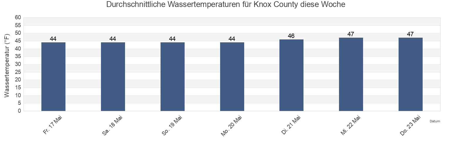
Knox County Wassertemperatur
Knox County Wassertemperatur für heute, morgen und diese Woche
Mehr Gezeiten- und Meeresinformationen für Knox County
Hochwasser heute
7 Tage Gezeiten
Wetter
Beißzeiten
Regionen und Städte in Knox County, Maine, United States
Andrews Island ESE of
Head of the Cape NNW of Penobscot Bay
Pond Island-Western Island
Birch Island northwest of
Heron Neck Green Island
Pond Island-Western Island between
Bradbury Island ESE of
Hog Island ESE of
Port Clyde
Browshead Vinalhaven Island NNW of
Hope
Pulpit Harbor (North Haven Island)
Burnt Coat Harbor (Swans Island)
Isle Au Haut
Pumpkin Island north of
Burnt Coat Harbor Swans Island
Isle au Haut 0.8 mile E of Richs Pt
Rockland
Weitere Standorte anzeigen
Burnt Island-Oak Island
Kimball Island
Rockland Harbor Breakwater
Burnt Island-Oak Island between
Laireys Island south of
Rockport
Camden
Lasell Island SSW of
Russ Island N of Deer Island Thorofare
Camden Harbor
Leadbetter I. SSW of southern tip
Saddle Island northwest of
Casco Passage east end Blue Hill Bay
Leadbetter Island E of southern tip
Saint George
Clam I. NW of Deer I. Thorofare
Leadbetter Island northwest tip of
Scrag Island 0.3 nautical mile SW of
Compass Island 0.4 nmi. ENE of
Little Deer I.-Sheep I.
Sheep Island
Crabtree Pt. North Haven I. NNE of
Little Deer I.-Sheep I. between
South Thomaston
Crotch Island east of
Little Deer Isle
Stonington (Deer Isle)
Cushing
Little Eaton Island NNE of
Stonington Deer Isle
Dodge Point-Monroe Island
Little Hurricane Island southwest of
Swains Ledge 0.3 nautical mile SW of
Dodge Point-Monroe Island between
Mackerel Cove
Tenants Harbor
Dogfish Island NNE of
Mark Island 0.3 nmi. SSE of
The Reach NNE of Green Island
Dyer Point
Mark Island north of
Thomaston
Eagle Island 0.4 nautical mile S of
Matinicus Harbor (Wheaton Island)
Triangle Ledge SSE of
East Goose Rock NNE of
Matinicus Harbor Wheaton Island
Vinalhaven
Ensign Island SSE of
Moore Harbor W of
Vinalhaven (Vinalhaven Island)
Fisherman Island Passage
Nash Point
Vinalhaven Vinalhaven Island
Fox Island Thorofare
Naskeag Harbor
Warren
Friendship
Northwest Harbor
Warren Island northwest of
Fundy (offshore 6)
Oceanville Deer Isle
White Islands northeast of
Great Spruce Head Island west of
Otis Cove
Widow Island-Stimpson Island
Grog Island E of Deer Island Thorofare
Owls Head
Widow Island-Stimpson Island between
Hat Island SE of Jericho Bay
Penobscot Bay
Head Harbor
Pickering Island south of
Gezeiten in der Nähe von Knox County
South Thomaston
Rockland
Thomaston
Dyer Point
Rockland Harbor Breakwater
Sheep Island
Owls Head
Dodge Point-Monroe Island between
Dodge Point-Monroe Island
Fisherman Island Passage