DE
°F
Ändern Sie Ihre Maße
Meters
Feet
°C
°F
km/h
mph
kts
am/pm
24-hour
Deine Einstellungen wurden aktualisiert. Klicken Sie hier, um die Seite zu aktualisieren
Ändere deine Sprache
Deutsch
Español
Italiano
Nederlands
中文
English
Français
日本語
Português
Heute
7 Tage
Wetter
Angeln
Meer
United States
Gezeiten
South Carolina
Gezeiten
Beaufort County
Gezeiten
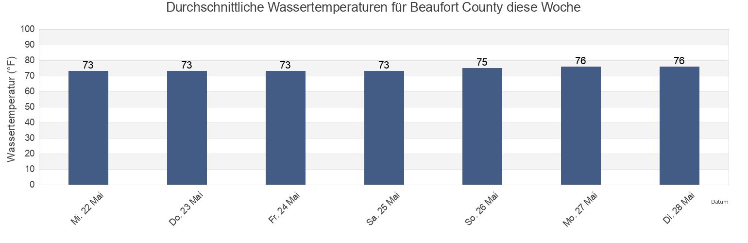
Beaufort County Wassertemperatur
Beaufort County Wassertemperatur für heute, morgen und diese Woche
Mehr Gezeiten- und Meeresinformationen für Beaufort County
Hochwasser heute
7 Tage Gezeiten
Wetter
Beißzeiten
Regionen und Städte in Beaufort County, South Carolina, United States
Albergottie Creek
Coosaw Island South of Morgan River
New River (Rt. 170 Bridge)
Albergottie Creek Rt. 21 Bridge
Corning Landing Whale Branch
Otter Island
Ashe Island Cut St. Helena Sound
Cowen Creek (Route 21 Bridge)
Parris Island (Marine Corps Recruit Depot)
Ashe Island Cut SW of Coosaw River
Cowen Creek Rt. 21 Bridge
Parris Island Beaufort River
Ashepoo Coosaw Cutoff
Daufuskie Island
Parris Island Lookout Tower Broad River
Ashepoo Coosaw Cutoff ICWW
Daws Island SE of Broad River
Parris Island Marine Corps Recruit Depot
Weitere Standorte anzeigen
Ashepoo River off Jefford Creek entrance
Daws Island south of Chechessee River
Parrot Creek Coosaw Island
Bailey's Landing
Distant Island (Cowen Creek)
Pelican Bank St. Helena Sound
Baileys Landing (Okatee River Colleton River)
Distant Island Cowen Creek
Peters Point (St. Pierre Creek)
Battery Creek (4 Mi. Above Entrance)
Distant Island Creek (Upper End Cowen Creek)
Pinckney Island (Mackay Creek Chechessee River)
Battery Creek 4 Mi. Above Entrance
Distant Island Creek Upper End Cowen Creek
Pinckney Island Mackay Creek Chechessee River
Bay Point Island S of Broad River entrance
Dolphin Head
Pine Island (Ramshorn Creek Cooper River)
Beaufort
Edding Point (Edding Creek)
Pine Island Ramshorn Creek Cooper River
Beaufort Airport Beaufort River
Edding Point Edding Creek
Pine Island South Edisto River
Beaufort Beaufort River
Edisto Beach (Edisto Island)
Port Royal
Beaufort River
Edisto Beach Edisto Island
Port Royal Plantation (Hilton Head Island)
Beaufort River Entrance
Edisto Marina (Big Bay Creek Entrance)
Port Royal Plantation Hilton Head Island
Bluffton
Edisto Marina Big Bay Creek Entrance
Port Royal Plantation Tower east of
Braddock Point (Hilton Head Island)
Egg Bank St. Helena Sound
Port Royal Sound
Braddock Point Hilton Head Island
Euhaw Creek (2.5 Mi. Above Entrance)
Ramshorn Creek Light E of Cooper River
Braddock Point SW of Calibogue Sound
Euhaw Creek 2.5 Mi. Above Entrance
Rose Dew Creek
Brickyard Point (Brickyard Creek)
Fenwick Island Cut South Edisto River
Rt 170 bridge
Brickyard Point Brickyard Creek
Fort Fremont
Sams Point (Lucy Point Creek)
Broad Creek (Hilton Head Island)
Fripp Inlet
Sams Point Lucy Point Creek
Broad River Bridge S of Broad River
Fripp Inlet Bridge
Sams Point Northwest of Coosaw River
Broad River Entrance Point Royal Sound
Fripp Inlet Fripp Island
Savage Creek (Bull Creek)
Bull Creek (Bull Island South Cooper River)
Fripp Island
Savage I. Savage Creek Bull Creek
Bull Creek Bull Island South Cooper River
Haig Point (Daufuskie Island Cooper River)
Scott Creek 0 5 mi above ent Big Bay Creek
Bull Island North
Haig Point Daufuskie Island Cooper River
Shell Point
Burton
Haig Point Light NW of Cooper River
Shell Point (Hwy. 170 Bridge)
Byrd Creek Entrance SE of Broad River
Harbor River Bridge
Skull Creek (North Entrance Hilton Head Island)
Calibogue Cay (Broad Creek Hilton Head Island)
Hilton Head
Skull Creek (South Entrance Hilton Head Island)
Calibogue Cay Broad Creek Hilton Head Island
Hilton Head Island
Skull Creek north entrance
Calibogue Sound
Hunting Island
Skull Creek North Entrance Hilton Head Island
Callawassie Creek (Colleton River)
Hutchinson Island
Skull Creek south entrance
Callawassie Island (South Colleton River)
Hutchinson Island Ashepoo River
Skull Creek South Entrance Hilton Head Island
Callawassie Island Bridge (Colleton River)
Hwy 170 bridge
South Edisto River entrance
Callawassie Island Bridge Colleton River
Jenkins Creek (1 Mi. Above Entrance)
Southeast Channel entrance
Callawassie Island South Colleton River
Jenkins Creek (Polawana Island)
Spanish Wells Calibogue Sound
Capers Creek (Cowen Creek St. Helena Island)
Jenkins Creek 1 Mi. Above Entrance
Station Creek (County Landing)
Capers Creek Cowen Creek St Helena Island
Jenkins Creek Polawana Island
Station Creek (West End)
Capers Island (Trenchards Inlet)
Johnson Creek Bridge (Hunting Island)
Station Creek County Landing
Capers Island Trenchards Inlet
Laurel Bay
Station Creek West End
Carters Dock (Big Bay Creek)
Lemon Island
Summerhouse Point (Bull River)
Carters Dock Big Bay Creek
Lemon Island South Chechessee River
Summerhouse Point Bull River
Chechessee Bluff (Chechessee River)
Little Barnwell I. E of Whale Branch River
The Folly Hilton Head Island
Chechessee Bluff Chechessee River
Lucy Point Creek Entrance
Triton Head
Chowan Creek
MacKay Creek south entrance
Victoria Bluff
Clarendon Plantation
Marine Corps Air Station (Brickyard Creek)
Village Creek Cemetery
Club Bridge Creek Ent. (Trenchards Inlet)
Marine Corps Air Station Brickyard Creek
Village Creek Entrance
Coffin Point
Moreland Cemetery
Whale Branch Entrance
Colleton River Entrance
Morgan Island NE of Coosaw River
Whale Branch River
Combahee River
Morgan Island North end Coosaw River
Gezeiten in der Nähe von Beaufort County
Parris Island (Marine Corps Recruit Depot)
Parris Island Marine Corps Recruit Depot
Port Royal
Parris Island Beaufort River
Shell Point
Chowan Creek
Parris Island Lookout Tower Broad River
Distant Island (Cowen Creek)
Beaufort River
Distant Island Cowen Creek