DE
°F
Ändern Sie Ihre Maße
Meters
Feet
°C
°F
km/h
mph
kts
am/pm
24-hour
Deine Einstellungen wurden aktualisiert. Klicken Sie hier, um die Seite zu aktualisieren
Ändere deine Sprache
Deutsch
Español
Italiano
Nederlands
中文
English
Français
日本語
Português
Heute
7 Tage
Wetter
Angeln
Meer
United States
Gezeiten
Virginia
Gezeiten
Mathews County
Gezeiten
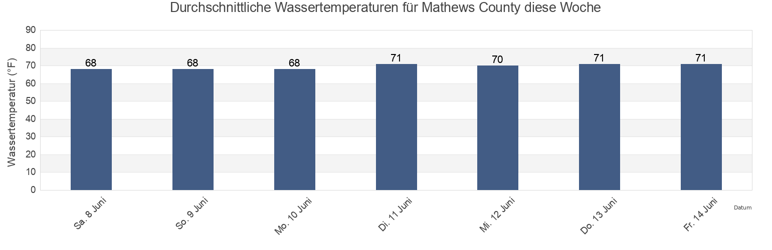
Mathews County Wassertemperatur
Mathews County Wassertemperatur für heute, morgen und diese Woche
Mehr Gezeiten- und Meeresinformationen für Mathews County
Hochwasser heute
7 Tage Gezeiten
Wetter
Beißzeiten
Regionen und Städte in Mathews County, Virginia, United States
Bethel Beach
Little Creek (Railroad Terminal), Chesapeake Bay
Windmill Point Light
Bland Point Piankatank River
Mathews
Windmill Point Light 2.2 n.mi. ESE of
Cherry Point
Mobjack (East River)
Wolf Trap Light
Gwynn Island
Mobjack East River
Wolf Trap Light 0.5 mile west of
Gwynn Island 1.5 n.mi. east of
New Point Comfort 2.0 n.mi. WSW of
Wolf Trap Light 1.4 n.mi. NNE of
Gwynn Island 8.0 n.mi. east of
New Point Comfort 4.1 n.mi. ESE of
Wolf Trap Light 2.0 n.mi. NW of
Weitere Standorte anzeigen
Horn Harbor Marina
Stingray Point 1.2 n.mi. NE of
Wolf Trap Light 5.2 n.mi. ENE of
Jackson Creek (Deltaville)
Stingray Point 5.5 miles east of
Jackson Creek Deltaville
SW Branch, Severn River, Mobjack Bay
Gezeiten in der Nähe von Mathews County
Bethel Beach
Mathews
Wolf Trap Light 2.0 n.mi. NW of
Horn Harbor Marina
Wolf Trap Light 0.5 mile west of
Wolf Trap Light
Wolf Trap Light 1.4 n.mi. NNE of
Mobjack East River
Mobjack (East River)
Gwynn Island 1.5 n.mi. east of