DE
°F
Ändern Sie Ihre Maße
Meters
Feet
°C
°F
km/h
mph
kts
am/pm
24-hour
Deine Einstellungen wurden aktualisiert. Klicken Sie hier, um die Seite zu aktualisieren
Ändere deine Sprache
Deutsch
Español
Italiano
Nederlands
中文
English
Français
日本語
Português
Heute
7 Tage
Wetter
Angeln
Meer
United States
Gezeiten
Virginia
Gezeiten
Northampton County
Gezeiten
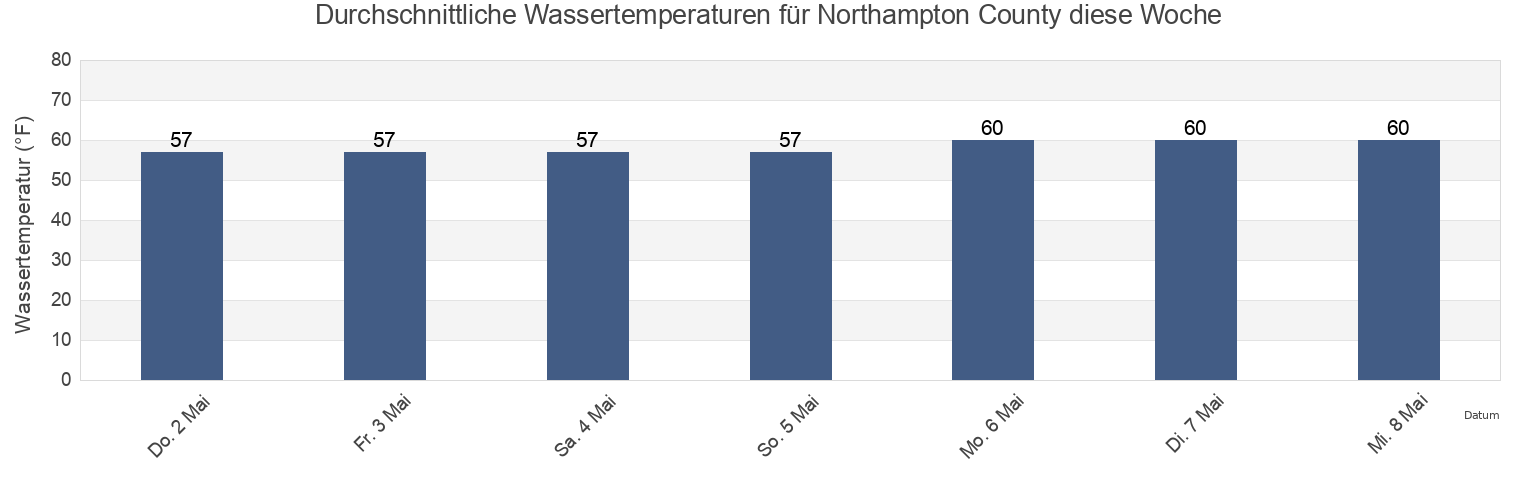
Northampton County Wassertemperatur
Northampton County Wassertemperatur für heute, morgen und diese Woche
Mehr Gezeiten- und Meeresinformationen für Northampton County
Hochwasser heute
7 Tage Gezeiten
Wetter
Beißzeiten
Regionen und Städte in Northampton County, Virginia, United States
Butler Bluff 2.1 n.mi. WSW of
Fishermans I. 0.4 mile west of
Kiptopeke Beach
Cape Charles
Fishermans I. 1.1 miles northwest of
Old Plantation Flats Lt. 0.5 mi. W of
Cape Charles City 3.3 n.mi. west of
Fishermans I. 1.4 n.mi. WNW of
Old Plantation Light
Cape Charles Coast Guard Station
Fishermans Island
Oyster Harbor
Cape Charles Harbor
Fishermans Island 0.5 n.mi. SW of
Sand Shoal Inlet (coast Guard Station)
Cape Charles off Wise Point
Fishermans Island 1.4 miles WSW of
Ship Shoal Inlet
Weitere Standorte anzeigen
Cherrystone Inlet
Fishermans Island 1.7 n.mi. south of
Smith Beach
Chesapeake Channel (bridge tunnel)
Fishermans Island 2.45nm south of
Smith Island (coast Guard Station)
Chesapeake Channel (Buoy '15')
Fishermans Island 3.2 miles WSW of
Smith Island Shoal southeast of
Chesapeake Channel (Buoy 15)
Great Machipongo Inlet (inside)
Wolf Trap Light 5.8 miles east of
Church Neck Point 1.9 n.mi. W of
Hog Island
Wolf Trap Light 6.1 n.mi. ENE of
Eastville
Hungars Beach
York River Entrance Channel (SE end)
Exmore
Kiptopeke
York Spit Channel N of Buoy 26
Gezeiten in der Nähe von Northampton County
Oyster Harbor
Eastville
Cherrystone Inlet
Cape Charles
Cape Charles Coast Guard Station
Cape Charles Harbor
Smith Beach
Hungars Beach
Sand Shoal Inlet (coast Guard Station)
Old Plantation Light