DE
°F
Ändern Sie Ihre Maße
Meters
Feet
°C
°F
km/h
mph
kts
am/pm
24-hour
Deine Einstellungen wurden aktualisiert. Klicken Sie hier, um die Seite zu aktualisieren
Ändere deine Sprache
Deutsch
Español
Italiano
Nederlands
中文
English
Français
日本語
Português
Heute
7 Tage
Wetter
Angeln
Meer
United States
Gezeiten
Washington
Gezeiten
Island County
Gezeiten
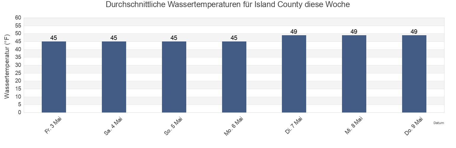
Island County Wassertemperatur
Island County Wassertemperatur für heute, morgen und diese Woche
Mehr Gezeiten- und Meeresinformationen für Island County
Hochwasser heute
7 Tage Gezeiten
Wetter
Beißzeiten
Regionen und Städte in Island County, Washington, United States
0.3 mile northeast of
Glendale
Point Wilson 0.8 mile east of
0.4 mile northeast of
Glendale (Whidbey Island)
Point Wilson 1.1 miles NW of
1.1 miles northwest of
Glendale Whidbey Island
Point Wilson 1.4 miles northeast of
1.6 miles northeast of
Greenbank
Point Wilson 2.3 miles NE of
Admiralty Head 0.5 mile west of
Greenbank (Whidbey Island)
Port Susan
Admiralty Inlet (off Bush Point)
Greenbank Whidbey Island
Port Townsend (Point Hudson)
Weitere Standorte anzeigen
Ala Spit (Whidbey Island)
Holly Farms Harbor
Port Townsend Canal
Ala Spit Whidbey Island
Holly Farms Harbor Holmes Harbor Whidbey I.
Possession Point
Ault Field
Holmes Harbor (Whidbey Island)
Reservation Bay
Bowman Bay
Kamen Point 1.3 miles southwest of
Sandy Point
Bush Point (Whidbey Island)
Kayak Point
Sandy Point (Whidbey Island)
Bush Point Light 0.5 mile NW of
Keystone Harbor
Sandy Point Whidbey Island
Bush Point Whidbey Island
Keystone Harbor (Admiralty Head)
Sequim Bay Entrance
Camano
La Conner (Swinomish Channel)
Skagit Bay 1 mi. S of Goat Island
Camano Island
La Conner Swinomish Channel
Skagit Bay channel SW of Hope Island
Cornet Bay
Lagoon Point
Smith Island 1.4 miles SSW of
Cornet Bay (Deception Pass)
Langley
Sneeoosh Point
Cornet Bay Deception Pass
Livingston Bay
Spee-Bi-Dah
Coupeville
Marrowstone Point
Stanwood (Stillaguamish River)
Coupeville (Penn Cove Whidbey Island)
Monroe Landing
Stanwood Stillaguamish River
Crescent Harbor
Mutiny Bay
Sunset Beach (Whidbey Island)
Crescent Harbor (Whidbey Island)
Mystery Bay (Marrowstone Island)
Sunset Beach Whidbey Island
Cultus Bay
Mystery Bay Marrowstone Island
Swinomish Channel Ent. Padilla Bay
Davis Slough
New Dungeness Light 2.8 miles NNW of
Tulare Beach Port Susan
Deception Island 2.7 miles west of
New Dungeness Light 6 miles NNE of
Turner Bay
Deception Pass (Narrows)
Nodule Point 0.5 mile southeast of
Turner Bay Similk Bay
Deception Pass St Park Bowman Bay Fidalgo I
Nodule Pt
Useless Bay
Dugualla Bay
Oak Harbor
Utsalady Bay
Dungeness
Olele Point 1.8 miles ENE of
Violet Point 3.2 miles northwest of
Elger Bay
Padilla Bay (Swinomish Channel Entrance)
West Beach
Fort. Ebey
Point Hudson 0.5 mile east of
Wood Island Harbor
Foulweather Bluff
Point Partridge (Whidbey Island)
Yokeko Point (Deception Pass)
Freeland
Point Partridge 3.7 miles west of
Yokeko Point Deception Pass
Gardiner (Discovery Bay)
Point Partridge Whidbey Island
Gardiner Discovery Bay
Point Wilson 0.5 mi. northeast of
Gezeiten in der Nähe von Island County
Coupeville
Coupeville (Penn Cove Whidbey Island)
Monroe Landing
Point Wilson 2.3 miles NE of
Keystone Harbor (Admiralty Head)
Keystone Harbor
Admiralty Head 0.5 mile west of
Point Wilson 1.4 miles northeast of
Fort. Ebey
Point Partridge Whidbey Island